
🗺️
Our own processing
Several models compared and merged into one reading, with the best high-resolution source picked for each country — automatically, wherever you look.
ExtremeCast doesn't copy a single model: it compares several weather models and produces its own reading, choosing for every country the best high-resolution source available — and adding a rain probability and a reliability index that tell you how much they agree.
Free, no sign-up, no ads in the map. Works on phone and desktop, installable as an app.
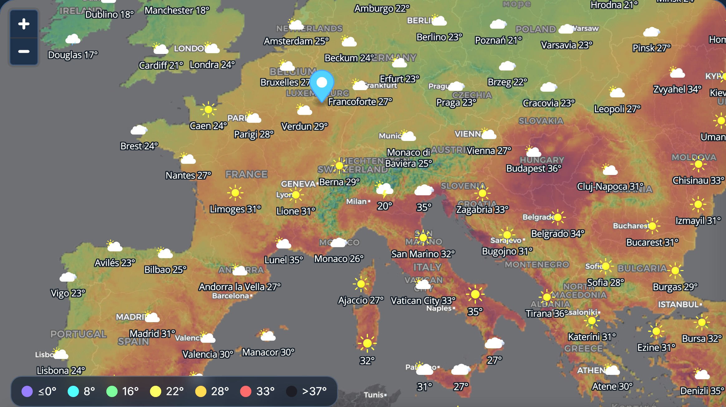
Zoom out and the map keeps going — from Lapland to Gibraltar, from Lisbon to Istanbul. Click anywhere and you get the full card.
Several models compared and merged into one reading, with the best high-resolution source picked for each country — automatically, wherever you look.
Our own calculation, from several independent models plus the behaviour of the surrounding area — because a shower is a local affair.
How much the models agree at your spot. High means solid, low means check again later — uncertainty shown, not hidden.
One slider scrolls the hours across the whole continent: sky, temperature and rain update together.
Type "Paris", "Den Haag", "München" or "L'Aia": 70,000+ places across Europe, local names and Italian exonyms alike.
No account, no paywall on the map. Add it to your home screen and it opens like a native app.
The same map also carries the radar of what is happening right now, pollen species by species, air quality and the state of the sea — for Italy and for the rest of Europe.
Observed precipitation over Italy and Europe, with echo intensity in dBZ point by point.
Not one lumped index: alder, birch, grass, mugwort, olive and ragweed, one by one.
PM2.5, PM10, ozone and nitrogen dioxide for the point you pick on the map.
Wave height, period and direction, with the water coloured by sea state.
See the areas affected by hail with the new ExtremeCast hail radar. The map distinguishes the areas involved and the estimated intensity of the phenomenon directly on the cartography, and also shows its track over time.

Experimental radar estimate: it shows where the radar detects signals consistent with hail and is not a measurement of hail at ground level.
Our severe-weather engine is trained and verified every night against Italian radar, ground stations and human storm reports. That's why these two are Italy-only today: we'd rather ship them where we can prove they work.
Hail, damaging gusts, torrential rain and storm cells mapped zone by zone up to 48 hours ahead, with e-mail alerts. Built on our own machine-learning engine, re-trained nightly and scored against observed radar.
Interface and content in Italian. Subscription product.
Read more (Italian) →Weather at the real altitude of 46,000 peaks, huts, passes and trails: snow line, ridge wind, cloud base, trail-by-trail forecast and a winter mode with ski slopes and snow bulletins.
Interface and content in Italian. Free base, Pro tools by subscription.
Read more (Italian) →ExtremeCast doesn't just relay a model: it compares several sources, picks the best one available for each area and merges them into a single reading — so the local detail isn't lost along the way.
When the models line up, the forecast is more trustworthy. When they diverge, we show it instead of hiding it: that's what the reliability index next to every value is for.
Data: Open-Meteo and national weather services (DWD, Météo-France, MeteoSwiss, GeoSphere, KNMI, DMI, MET Norway, CHMI, UK Met Office, ARPAE) — CC-BY. Model selection, rain probability and reliability index: ExtremeCast processing.
Yes. The weather map for Italy and Europe is free and needs no account. The subscription covers the Italian severe-risk product and the advanced mountain tools.
All of geographical Europe, from Iceland and Scandinavia to Turkey and Cyprus — plus Italy, of course. Every area is served by the best source available for it, merged into our own reading.
Up to 4 days, in 3-hour steps on the map and hour by hour in the location card.
Because it is verified against Italian radar, 3,750+ ground stations and human storm reports every single night. Extending it to another country means rebuilding that ground truth there first — we'd rather do that properly than paint colours we can't check.
Italian and English for now. More languages will follow together with localised forecast descriptions.